

Vancouver
Granville Bridge Connector
With a changing urban context, more people living within walking, rolling and biking distance from home, work and play, and shifting design intent with the goal of achieving Climate Emergency Response targets, the City of Vancouver has been actively engaging in improving the urban infrastructure to better reflect the values of modern-day Vancouver as a city that supports the use of all modes of transportation to be accessed by all users. This means, making roads accessible to vehicles, bikes and pedestrians alike.
The Granville Bridge Connector project has been on the City’s radar for a number of years, aiming to better reflect the needs of the city’s modern population. Originally built in order to connect two high speed, high traffic roadways that were never built, the bridge didn’t take into consideration the needs of cyclists and pedestrians. This has led many non-vehicle users to perceive the bridge as unsafe.

Recommended design. Source: City of Vancouver, 2020
The proposed project emphasizes the vital importance of the bridge in the context of a regional transportation network for pedestrians, cyclists, transit users and vehicles alike. Highlights from the project include:
Public use spaces, including public art, streets furniture and viewpoints
Wide sidewalks on both the East and West sides of the bridge
A bi-directional bike lane on the Westside that connects to the existing Arbutus Greenway, and 10th Ave. bike corridors to the South and to the proposed Drake St. bike lane to the North
Safety fences between vehicles and non-vehicle users, as well as suicide-prevention fencing
Six vehicle lanes are retained to keep efficient access for vehicles using the bridge

West side view. Source: City of Vancouver, 2020.
The proposed design is the result of many consultation processes, input from city staff and public initiative, and will cost an estimated 30-40 million dollars. Making roads safer and more comfortable for all road users is clearly a priority for the City of Vancouver and well depicted in this proposed design.
Implementing an urban infrastructure that reflects the accessibility and safety needs of all road users is important in looking towards more walkable communities around the province.

South end view. Source: City of Vancouver, 2020.
Check out the council report here>>
Check out the proposal for the Granville Bridge Connector here>>
Check out more on the City of Vancouver’s Transportation 2040 Plan here>>
Temporary road closures
The City of Vancouver has closed or limited access to select roads and paths to limit large gatherings and help you keep 2 m away from others while exercising and getting fresh air. Measures include slow streets in select neighbourhoods across the city, and roadway space reallocations on Beach Avenue and within Stanley Park. More >>
Pop-up Plazas
The City of Vancouver is allowing businesses to operate temporary pop-up plazas, giving people space to eat, visit, rest, or enjoy the weather while maintaining a safe distance from each other. More >>

Bowen Island
Multi-use Pathway
The Bowen Island Municipality multi-use pathway is in the process of being constructed and will be phased in over time. The pathway will create a linked active transportation network across the island, making walking a safe and accessible option to get around. The pathway connects residential neighbourhoods with key destinations.
The Bowen Island Transportation Plan 2018-2038 provides details on the new network to help understand the priorities and considerations of the project. Read more >>

Cardena Drive Safety Improvements
Identified as a priority in Bowen Island Transportation Plan, the Cardena Drive safety improvements were completed in late 2019. Improvements included many pedestrian-related infrastructure improvements including widening of the road to accommodate an accessible sidewalk and a bus shelter. Read more>>
Wayfinding Signage & Creative Crosswalks
Wayfinding signage will play a key role along the pathway to help permanent residents and visitors alike navigate the pedestrian paths and its key destinations.

Creative crosswalks near main destinations foster a sense of community and place while creating a fun and friendly pedestrian environment.


New Westminster
Streets for People
With a goal of reallocating 10% of the city’s road space to sustainable modes of transportation by 2030, the City of New Westminster has initiated a number of city-wide projects to support walking, wheeling and biking. These initiatives will support and facilitate healthy active living as part of daily life, improve access to local businesses, provide safe access to sustainable transportation infrastructure and support physical distancing.
In order to make safe transportation easier, the city has implemented a number of traffic calming and space reallocation measures including:
Reprogramming of traffic lights to prioritize and facilitate pedestrian crossings
Closure of the Northbound vehicle lane on the McInnes Overpass to allow more room for walking and cycling
Identification of areas for reallocation of space once resources become available
Cool Streets

This pilot project will initially target four local streets with quick and cheap interventions from August to the end of September 2020. The changes will not affect vehicle traffic directly, but rather encourage other modes of transportation to be prioritized. The proposed streets form a connected network that link open space in high density, low income and park deficient neighbourhoods while capitalizing on streets with a large, existing tree canopy. Read More>>

The initiatives being put in place by the City of New Westminster are valuable in giving pedestrians a safe and desirable network of places to walk. Activating streets as places, building a community around these places and encouraging residents to be members of this community is evident in the changes being put in place in New Westminster.
As a dense city with a small geographical area and a rich history, the changes being put in place will define the city as a walking destination and encourage individuals to explore its diverse urban area.
Enjoying one of New Westminster’s self-guided walking tours is a great way to observe, reflect, share, question and re-imagine the city and celebrate the urban environment.
Check them out:
Queens Park Walking Tour [3.3km]
Port Royal, Queensborough [6km]
Listen to two-term New Westminster councillor Patrick Johnstone talk about Streets for People with Dean Murdock on Episode 8 of the Amazing Places podcast.
New temporary guidelines for expanded sidewalk and on-street patios
In June 2020, New Westminster City Council endorsed an initiative that allows for an expedited process for restaurant and pub patio extensions which will provide businesses with the ability to increase their footprint to meet occupancy loads and serve patrons safely, while also activating the City’s commercial districts and streets. More >>

Langley - City

Mural Walk
The mural walk program is an initiative that allows local muralists to showcase their work on downtown Langley City walls. The Downtown Langley Business Association created a Mural Walk Guide that takes you on a walking tour to all the mural destinations. This program has been a hit on social media and an extremely popular outdoor attraction for locals and visitors!

Downtown Pedestrian Oriented One-way
The Downtown Langley Business Association and Langley City have worked together to create a pedestrian oriented shopping strip in the heart of downtown. This street allows traffic one-way to make room for extra parking, and elongated sidewalks that encourage people to walk and see the amazing small businesses and restaurants. Plazas and lanes have been created for event space and outdoor seating.

Parks and Trails
Langley City is home to over 15 parks and trails in only four square miles! These parks are home to many walking and biking trails and are noted for their extraordinary bird and wildlife watching. The Nicomekl trail follows the Nicomekl river right through the city and is great for walking or biking. Sendall Botanical Gardens is home to many species of plants and wildlife and has a Botanical greenhouse that is home to tropical species of plants.

Trail

Trail’s Window ArtWalk
The Arts community of Trail has gotten creative with how they can support and present the work of local Artists. The ‘Trail Window ArtWalk’ from September 2 - 30th, 2020 is an opportunity for Artists to create art installations inside downtown Trail business windows so that they may be seen during the month of September. The goal of this event is to support and pay artists, celebrate downtown businesses, and offer a way for the public to experience art at their own schedule without going inside a venue.

Storm the Stairs Virtual Challenge by the United Way
From August 26 - September 26, 2020 the United Way is hosting a virtual challenge in support of Youth Programs in the Greater Trail area. This event comes as a result of the pandemic, in an effort to support the community while staying distanced and safe. The virtual challenge can be completed by running, jogging, or walking from any location you choose. Complete your challenge at your own pace and track your steps and mileage your self.
Find out how to register and participate >>
Trail’s Columbia River Skywalk

Photo by Mark Hockley
The Columbia River Skywalk is one of the longest pedestrian suspension bridges of its kind in North America at 1000 feet landing to landing! The bridge is part of the Trans Canada Trail Society's Great Trail and spans the Columbia River from Rotary Park in West Trail to McQuarrie Street in East Trail. The bridge is bike and stroller friendly. The Skywalk won the Provincial 2018 Parks Excellence Award.

Historic Rock Walls
Get a little taste of Europe with a walking tour of Trail's historic rock walls, built to support the European-style streets in West and East Trail. The Rigatoni Ramble or the Haggis Hike will bring you face to face with the hundreds of rock walls, some 25 feet high, many of them carved by hand.

Covered Staircases
Trail has a total of 63 unique covered staircases, mainly located in West Trail. Built in the 1930s and 1940s, the staircases provided easier access to the downtown core and are a great way to stay out of the elements while out on a walk. Fun fact: stacked atop one another, the staircases would equal 6,610 vertical feet or 1.25 miles! If you're looking for a workout with a side of culture, look no further!

Murals and Historic Plaque Tour
For the active heritage lover, spend some time in downtown Trail admiring the historically-themed murals and the many plaques featured on downtown buildings. Like what you see? A companion guide is available for purchase at the Trail Riverfront Centre, complete with a map of plaque and mural locations.
Find out more information about walking initiatives in Trail >>

Coquitlam
Temporary Outdoor Space Expansion Program - Phase 2
In an effort to facilitate the reopening of local businesses and in aid of Coquitlam’s economic and social recovery from the COVID-19 pandemic, the City developed this program to allow patios and outdoor spaces on City rights-of-way including sidewalks and curb-side parking stalls.
The extra space is intended to allow patrons more space to maintain physical distancing. Examples could include:
Restaurant or table seating;
Merchant displays (e.g. clothing racks, outdoor tables, etc.);
Pick-up or drop-off kiosk or customer queuing; or
Checkout areas.
School Walkability Program

Banting Middle School’s Best Routes Map
In partnership with TravelSmart, a Middle School Walk-Bike Program was developed for Coquitlam’s eight middle schools. This program includes “Best Routes Maps’ and ‘School Travel Plan’ information for students.
See the maps and plans for the eight participating middle schools:
Banting Middle School: Best Routes Map | School Travel Plan
Como Lake Middle School: Best Routes Map | School Travel Plan
Hillcrest Middle School: Best Routes Map | School Travel Plan
Maillard Middle School: Best Routes Map | School Travel Plan
Maple Creek Middle School: Best Routes Map | School Travel Plan
Montgomery Middle School: Best Routes Map | School Travel Plan
Scott Creek Middle School: Best Routes Map | School Travel Plan
Summit Middle School: Best Routes Map | School Travel Plan
Neighbourhood Improvement Program
In 2018, the Neighbourhood Improvement Pilot Program was developed to improve 10 neighbourhoods across Coquitlam. Improvements included street lights repainted, graffiti removed from city-owned utility boxes, wheelchair ramps installed at intersections, road lines remarked, faded traffic signs replaced, overhead overhead street name signs at signalized intersections replaced with ones that illuminate internally, overgrown vegetation removed and fire hydrants repainted.
This program is continuing into 2020 with the retrofitting of concrete barriers with letdowns and tactile pads.
Transit Related Road Infrastructure Program (TRRIP)
This program aims to have all bus stops be wheel-char accessible through the installation of landing pads, making a wider sidewalk to allow for easier maneuverability.
The Addition of Durant Linear Park

Photo From: TriCity News
On August 12, 2020, the addition of Durant Linear Park was unveiled by the City of Coquitlam and creates pedestrian and cyclist trail connections between Guilford Way and Nash Drive. The addition includes 212 steps climbing a 110-foot elevation, creating.a new space for exercise and transportation opportunities to Coquitlam’s community members.
New ‘Coquitlam Crunch alternative’ unveiled in Coquitlam >>

Sechelt
May 20th, 2020, The Sechelt council approved a street patio pilot project in the downtown area, as requested by the Sechelt Downtown Business Association (SDBA). The changes transform a section of Cowrie Street, between Trail Avenue and Inlet Avenue, into a pedestrian-only area, incorporating street patios and sidewalk sales.
“Adorned with plants and furniture, an enclosed patio will increase the vibrancy to our downtown offering a much needed gathering space which downtown Sechelt currently lacks,” Legge (SDBA president) said of the SDBA proposal.
More>>

Whistler
The Village of Whistler core is a pedestrian-only space adding to the quaint mountain experience of the village. This leaves space in the urban area for a leisurely stroll along the cobblestone streets and the enjoyment of patios surrounded by beautiful mountains. Low-storey buildings allow for lots of light to hit the walkways.

Grand Forks
Market Avenue opens up for pedestrians and patios.
Two blocks of Grand Forks’ Market Avenue will close to vehicle traffic on June 29 for three months, as the downtown businesses experiment with a pedestrian-only strip through the city’s core.
The purpose […] is to give businesses the opportunity to use the sidewalks and parking areas for expansion of their business, while maintaining the main street as a walkway,” said Sarah Dinsdale, marketing coordinator for the Boundary Country Regional Chamber of Commerce (BCRCC).

Salmon Arm
Salmon Arm’s Alexander Street to be open to foot traffic only on Saturdays
Downtown Salmon Arm’s Alexander Street will be open to foot traffic only every Saturday from May 27 through to September 5th, follow a decision at the Downtown Salmon Arm annual general meeting.
“This is a project we’ve been talking about for quite a number of years – it’s opening Alexander to foot traffic only. It’s been going in many cities for quite a few years but in light of the COVID pandemic, there has been an even bigger light shed on the fact that we need some more space on our streets.”
More>>

Merritt
An Active Transportation Plan is Underway in Merritt!

Merritt is currently in the process of developing an Active Transportation Plan. The City is conducting public consultations to ensure that the final plan is inclusive and forward-thinking. Their goal is to make Merritt more walkable, likeable, sustainable and dynamic!
During the second phase of Merritt’s Active Transportation Plan, a survey was conducted to understand existing conditions and opinions of the community members.
Here are some of their walking-related results:
75% said that driving was their main mode of transportation;
While 33% said that they use Merritt’s current trail network for recreational purposes regularly, 58% said that they never use the trail network for commuting;
Exercise and recreation were the most significant reasons for walking while commuting was the least significant;
Lack of trails and sidewalks dedicated to walkers was noted as a significant barrier;
Safety concerns such as poor lighting, sidewalk conditions, vehicle speed and intersection safety were also noted as prominent barriers;
The most significant area of Merritt where people would like to see active transportation improvements was the City Centre.
With Merritt being a small city in BC and many community members living in a suburban and rural setting, understanding current transportation methods and barriers are very important for implementing future active transportation improvements. Merritt is leading as a great example for what is possible when active transportation planning is prioritized!
Economic Recover Plans and Walking in Merritt
Merritt is in the process of creating an Economic Recovery Task Force and has outlined some project ideas related to walking:
Downtown Pedestrian Zone
The idea of having Quilchena, between Voght and Garcia, as foot traffic only each Wednesday during lunchtimes is currently being discussed. Pedestrian only traffic on Friday evenings/Saturday will also be brought forward as options.
Use of Street Parking for Patios
There are opportunities for street parking and plaza parking to be converted into temporary patios to make room for distance-friendly dining at local restaurants. If this temporary plan results in favourable responses, there may be an opportunity to make this a permanent plan.
Tourism in Merritt

West Kelowna
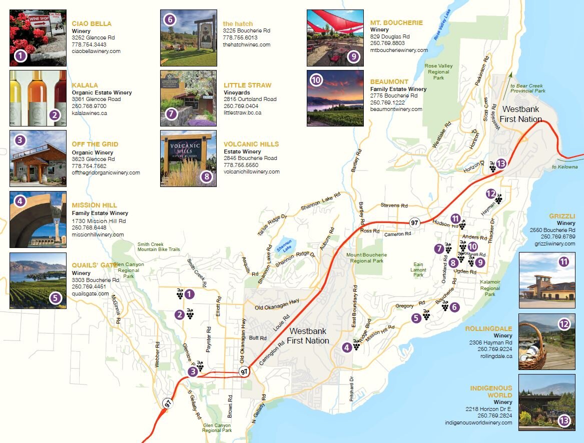
Westside Wine Trail
Officially opening on June 13, 2019 the Boucherie Road Wine Trail transformed a busy rural road into a multi-use transportation corridor that connects multiple local wineries. There is now 5,700 m2 of cycling track and 4,100 m2 of concrete sidewalk for pedestrians to safely use the roadway along with motor vehicles. Funding partners for this project included Bike BC (BC Ministry of Transportation and Infrastructure); ICBC Road Improvement Program and BC Hydro’s Community Re-greening Program.
15 Reasons to Travel the Westside Wine Trail >>
Gellatly Bay Recreation Corridor

The Gellatly Bay Recreation Corridor was identified as the most popular trail owned by the City in the Recreational Trails Masterplan and as the most prominent multi-use facility in the Pedestrian and Bicycle Infrastructure Plan. It offers access to walkers and cyclists from Rotary Beach Park south through the off leash Dog Beach area to the CNR Wharf to Willow Beach Park, Gellatly Boat Launch, Marina Park, Gellatly Landing Park, Gellatly Nut Farm Regional Park and further onto Pebble Beach Park at the south end of Whitworth Rd.
Read the Recreational Trails Masterplan (2013) >>
Read the Pedestrian and Bicycle Infrastructure Plan (2016) >>

Smithers
Connecting missing links, expanding the network.
The Town of Smithers is currently working on expanding their existing pedestrian and cycling networks. The proposed sidewalks will largely contribute to a more connected pedestrian network, encouraging walking as an accessible, safe and healthy option for local trips and exercise.

Proposed pedestrian network.

Existing pedestrian networks.

Kitimat
Reallocating space for pedestrians
The District of Kitimat has approved a temporary outdoor plaza in Lower City Centre parking lot. The piloted pedestrian plaza creates a safe space for pedestrians to sit and enjoy a variety of food trucks while being surrounded by vegetated planters. The 2020 Summer Plaza will provide a place to gather in small groups while maintaining physical distancing.

2020 Summer Plaza in progress.
For more information about the 2020 Summer Plaza, click here.

Castlegar
Open Streets Pilot - COVID-19 Response Plan for Local Businesses
The City of Castlegar has initiated a six-month Open Streets Pilot Project in support of the business community by making streets, sidewalks, parking areas and open spaces available to assist businesses in meeting the physical distancing measures of the Province and to encourage residents to get outside and feel safe.
Complete Streets Project - Winner of the UBCM “Excellence in Sustainability” Community Award
The City of Castlegar undertook an $8 million project to turn the community’s main roadway into a “complete street.” The project transformed a commercial street into the centrepiece of the downtown core using green infrastructure to attract citizens and businesses.
Annual Castlegar Sculpturewalk

Castlegar is the sculpture capital of Canada! Sculpturewalk is an outdoor exhibit of original sculptures by local and international artists, located on a walking tour in downtown Castlegar. It is now in its 10th anniversary year, with 26 sculptures located across the city. Sculpture walk has recently expanded to communities across the region - visiting Kaslo, Nakusp, Penticton, Creston, Rossland and Nelson, BC.

Burnaby
City of Burnaby’s Active Sidewalks, Open Businesses Program Expands
The City of Burnaby’s Active Sidewalks, Open Businesses program is expanding, giving local businesses the ability to temporarily use their outdoor space such as on-site parking spaces for retail areas or patios for customers. More >>

Powell River
City of Powell River approves patios and parklets

Full staff report and motion (agenda item 8.2) from the June 24, 2020 City of Powell River Regular Council Meeting.
City of Powell River Council has passed two bylaws that will allow for sidewalk patios and parklets.
“Staff understood the report was to offer solutions that would allow businesses, property owners and organizations in the city’s commercial precincts to expand and occupy public lands to accommodate people more appropriately through the pandemic and potentially into the future.” More >>

Nelson
More downtown parking spaces to be turned over to sidewalk cafés
Nelson Council passed legislation to provide additional flexibility in regards to the use of on-street parking spaces to augment seating in the city’s downtown restaurants. “Essentially, the bylaw ensures that the sidewalk cafés are well designed, allow for pedestrian movements and promote an active downtown.” More >>

Victoria
Physical Distancing at Beacon Hill Park and Dallas Road
The City of Victoria made it easier for people to maintain physical distance in Beacon Hill Park and along Dallas Road by restricting vehicle access and realigning parking. In addition to vehicle access and parking restrictions, City staff are out in public spaces to encourage physical distancing. More >>
City Creating Physical Distancing on Local Streets
Beginning in James Bay in April, the City of Victoria has established temporary physical distancing zones in areas with grocery stores, pharmacies and other essential services. City staff are prioritizing high-traffic locations with narrow sidewalks. Each location will have a customized plan that maintains transit stops and vehicle circulation and crosswalks. More >>

Oak Bay
Council Supports Use of Public Spaces to Support Small Businesses
Oak Bay Council resolved today to relax the Streets and Traffic Bylaw to expedite the approval process of temporary sidewalk or parking stall patios. In addition, Council also resolved that application fees and administration fees for the purposes of temporary sidewalk or parking stall patios will not be collected. The District believes that these temporary relaxations will allow for the municipality to support these innovative solutions for small businesses, while still enabling the public to safely physical distance on our sidewalks. More >>